PETER PAPESCH H’60 ADVOCATES FOR A 14-MILE DIKE TO PROTECT GREATER BOSTON FROM SEA LEVEL RISE*
Peter Papesch along with Franziska Amacher and A. Vernon Woodworth had the following
published by MassInc’s Commonwealth Magazine on January 14, 2018.
A recent story in the Boston Globe, with the headline “Floods seen as warning of Boston’s future,” described how sea level rise and storm surge effects predicted for later in the century made their appearance during last week’s bomb cyclone. The article also mentioned various studies on what to do about sea level rise planned or underway by the city of Boston, its Green Ribbon Commission, and the University of Massachusetts.
We submit that the options explored by these studies share a glaring deficit – Boston and adjacent metropolitan cities and towns will not be completely protected. Because these municipalities are located in the metropolitan Boston estuary (the outlet for the Charles, Mystic, and Neponset Rivers, among others), nearly every option studied so far will be circumvented by higher sea levels and storm surges via Revere and Lynn to the north and via Nantasket Beach to the south. The studies also ignore river flooding altogether.
We offer a more ambitious protective option than any proposed so far by the local governments of the metro Boston estuary. We call it Metro Boston DikeLANDS, and we believe it is more practical and creative and has the potential to provide a significant return on the enormous investment required, unlike the other options discussed.
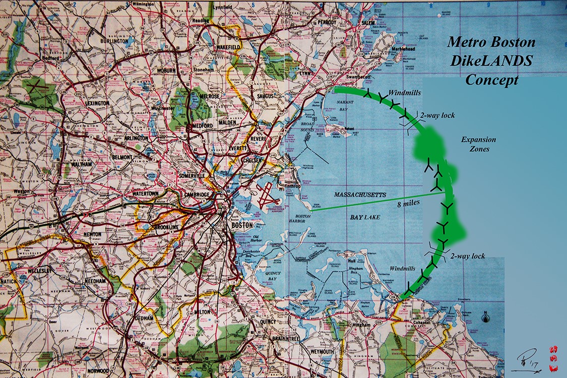
The metropolitan Boston estuary is uniquely different from many others around the nation. It is protected on its flanks by the shoulder highlands of Swampscott and Cohasset. The Metro Boston DikeLANDS proposal takes advantage of the estuary’s unique geological characteristics.
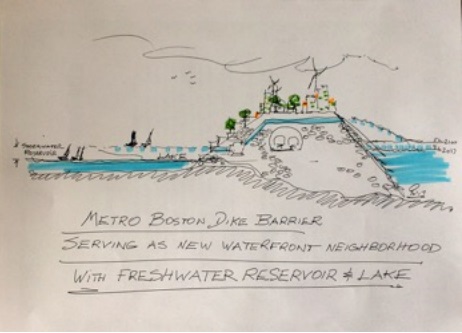
Our idea is an expansion of one proposed originally by Antonio DiMambro when he won the 1988 Boston Society of Architects competition. We propose building a 14-mile dike barrier between the shoulder highlands of Cohasset and Swampscott. The dike would be located some eight miles out from Deer Island, complete with residential and commercial developments, windmills, solar collector farms, and recreational areas. A simple dike barrier with a 200- foot-wide top and reaching 120 feet from seafloor to storm-surge top would require some 246 million cubic yards of material. Bi-directional locks could provide access for all crafts, protecting Boston’s commercial activity and its waterfront integrity.
The new dike system will prevent storm tides from inundating the entire metropolitan estuary while allowing rivers to discharge their water into a harbor reservoir capable of holding more than 10 billion gallons of river-fed water. The gradual transformation of the reservoir into a fresh-water lake could permit it to act as a source of fresh water for the drinking water needs of southeastern Massachusetts communities. The drinking water supplies of those communities are increasingly threatened by rising sea levels, which are making groundwater increasingly brackish.
By lowering the reservoir level to half the current tidal range, the cherished Boston Harbor Islands and their recreational potential would be protected. (With the new dike system, however, the islands eventually would be surrounded by fresh water rather than sea water.)
At a cost of $100 per cubic yard, with two bi-directional shipping locks of $500 million each (plus soft and contingency costs), this macro-engineering and macro-economic project would probably cost between $30 billion and $50 billion. The 200-foot wide top of the 14-mile stretch would create 68 acres of new dike lands, which in turn would need to be supported by a complete infrastructure system of water, sewer, electricity, and transportation (high-speed mag-lev trains to connect the north and south shores without going through downtown are a possibility). New all-electric buildings would become the customers for renewable energy provided by new windmills, which would take advantage of the offshore winds, and solar-tracking photovoltaic installations.
In many respects, the Metro Boston DikeLANDS proposal would bring economic as well as ecological sea change parameters in line with the resiliency required to meet the challenges of rising sea levels and climate change impacts.
A project of this scope requires major public as well as private support to overcome all the foreseeable environmental changes and regulatory obstacles to such a large project. The project could help pay for itself if the newly-created, flat-top area of the dike, amounting to some 68 acres, was sold as waterfront property at between $3 and $7 million per acre. That would raise between $100 billion and $400 billion (after return on invested capital) and possibly more if the dike’s landward slope facing the metro Boston estuary were also developed for terraced housing. Still more money could be raised if additional expansion zones or peninsulas were created along the dike barrier.
Boston began as a slight peninsula and has grown steadily in step with the needs of the times. Our enterprising forebears – investors as well as policymakers – had the vision to fill tidal flats to create Boston’s Back Bay in the 19th Century. Their descendants are equally capable of undertaking a comparably visionary project in the 21st Century, one which would serve double duty as protective flood system and newly created waterfront property, reshaping and enhancing the entire metropolitan area.
Peter Papesch is a retired architect-developer and educator; he worked internationally as a regional planner and urban designer. Franziska Amacher is an architect with over 25 years of promoting and designing sustainable communities. A. Vernon Woodworth is an architect and code consultant with AKF Group, and a faculty member at the Boston Architectural College. All three are members of the Boston Society of Architects, which is a chapter of the American Institute of Architects.